

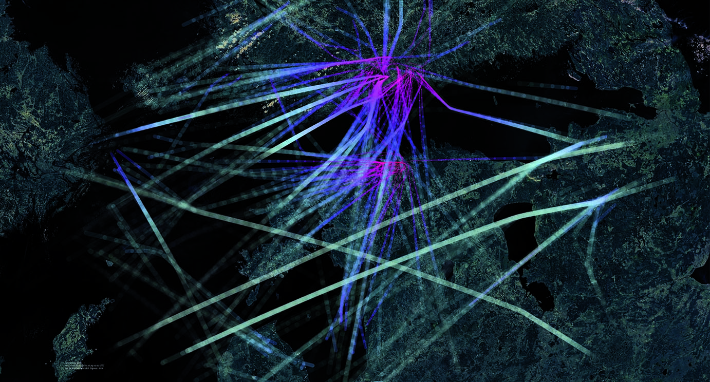
Raul Kalvo. Aerogramm. Ongoing research and art project visualizing aviation, flu and dataflow.
Please say a word about your MA work, the Aerogramm project, shown in 2011 at the Hobusepea Gallery in Tallinn. The curator, Maarin Mürk, noted in the introduction to the exhibition that “the first thing you notice about Raul Kalvo’s drawings is their aesthetic side: the whole world map is covered with a fine network of rays; the rays gather at one point and then separate, in order to come together somewhere else.” You convey a lot of information here by packing it into fine networks.
Aerogramm opened many themes for me, some of which are very practical, and others more philosophical. There are a lot of data about aviation, luckily quite easily accessible. Even if we look at flights only as connections, there are at least 7000 aircraft in the air at any given moment. All of that data makes you realise that the list in text form does not reveal much. Hence a very practical question: who should deal with the data, and how should they be presented? It is logical to link the data in a geographical context. A background system emerges, and no aircraft can exist outside it. The geographical background has a clear visual outlet via a map. It is necessary to make information perceptible in any kind of mapping. Mapping can also be used in other situations: colours, for example, fall into a spectrum, which is easy to measure in wavelengths. If a colour is missing, it will be obvious. This model also offers an opportunity to move from one colour to the next. The same goes for aeroplanes: it’s obvious when there is heavy traffic. All flights must move across a map smoothly. Mapping as a method or even a metaphor has been important to me in many subsequent projects, as it offers clarity and understanding about data.
As for Aerogramm, I often think about travel, the meaning of which has changed considerably due to aviation. Before there was extensive flying, travel was going from one place to the next, whereas now travel seems to be about staying in the same place. Travelling as an activity has disappeared. By quietly moving from one culture to another, one could gradually adapt to time and climate. Now we arrive before we even begin to go anywhere physically. Arriving at an aeroport gate, waiting for the flight, you already sense the cultural and social environment of your destination.
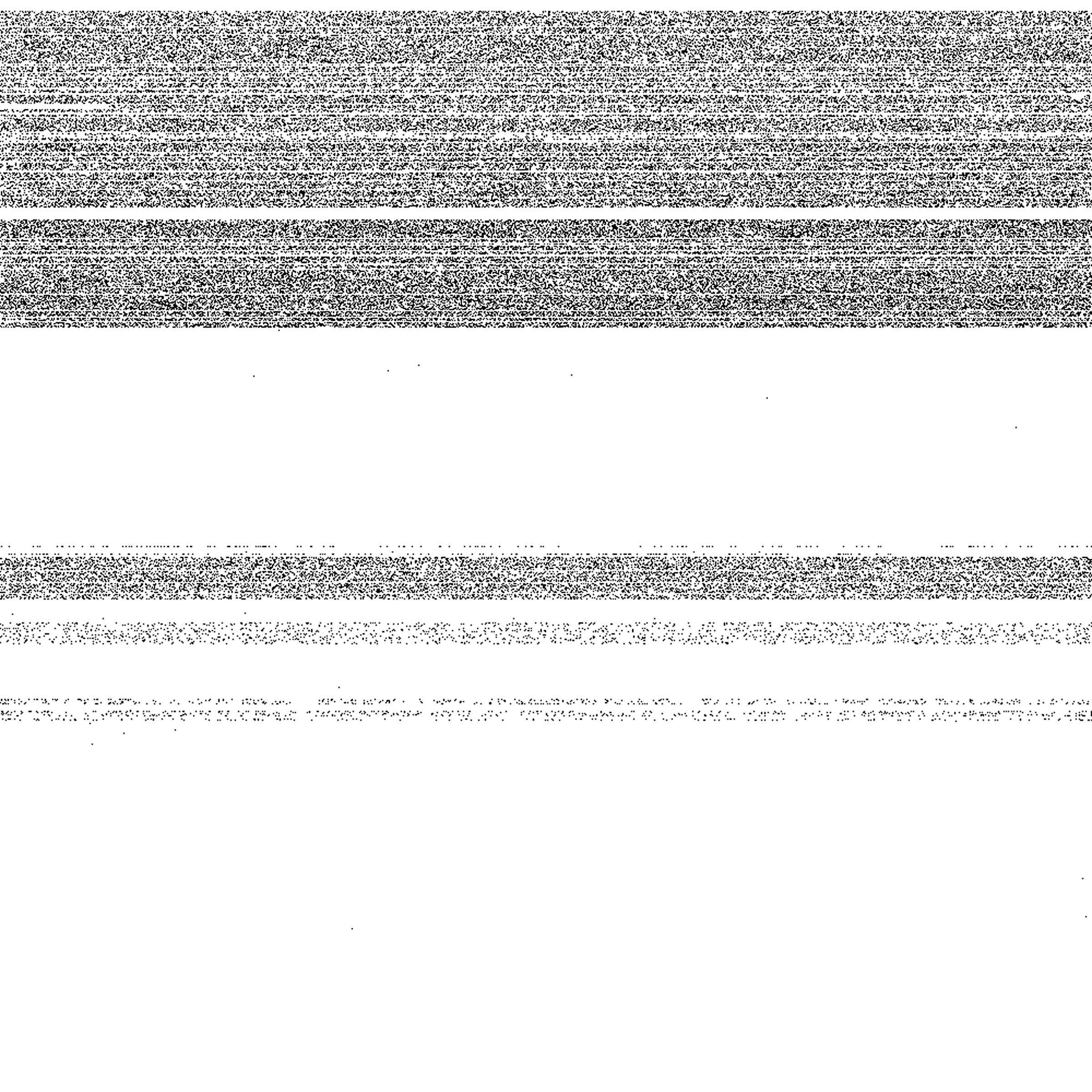
Raul Kalvo. Telephone numbers from 5M to 6M. Raul Kalvo: In 2009 I tried to find out what telephone numbers are being used in Estonia. Black pixels are the numbers in use and white are free. The upper left corner is number 50 00000 and the right corner below is 60 00000. It is interesting to mention that some floating numbers belong to embassies.
In cooperation with Andres Sevtšuk, you produced the architectural solution for the library pavilion of the Singapore University of Technology and Design. Would you tell us about this cooperation?
In spring 2012 I joined the City Form Lab, operating at the Singapore University of Technology and Design, where our first project was the addition to the library. It gradually evolved into a huge project: a pavilion with a crustal structure. The project involved thorough research, which tackled a geometric solution in which a double-wall structure would make it possible to construct crustal surfaces so that all details were cut out two-dimensionally. The solution made it possible to build rather complicated structures using simple and available means. We also constructed a number of software tools, mainly tools to model complex forms, which according to the general form parameters interpreted geometry in terms of the unique details necessary to realise the building. We therefore did not actually design any details, only large finite geometry.
Besides modelling, other significant software tools help maintain and offer information to highly diverse parties. An architect needs a precise spatial model to make aesthetic decisions. An engineer needs lines to calculate loads. A model needs surface spreading that is easy to fold and glue. A producer needs typewritten (G-Code) cut files with illustrative drawings. Despite the building’s unique and elaborate form, the builders of our pavilion did not need drawings. The aim was to make the assembling of the pavilion simple. How could we make the assembling of a structure with seven thousand unique details logical and understandable to anyone? To find a solution, we gathered all the necessary information details, which were cut into the details in the factory. The assembling proceeded smoothly, as it was possible to focus on one detail at a time, and there was no chance of making a mistake.
One of the peculiarities of architecture is that even if you have one compact model, it will be interpreted. You just have to hope that after all the interpretations by various parties everything falls into its proper place in the physical world.


What are your next big (joint) projects?
We are currently working on very practical projects on a larger scale. One of them is software for the design-friendly programme Rhino3D to research urban networks (roads, streets and corridors). It will bring many GIS functions over into the design environment, which will help unite analytical and design methods.
